Following a dry autumn season, El Nino flexed its muscles and the water tables are in good shape across the D.C. metro area.
Even as late as Dec. 12, D.C. was in an abnormally dry spell thanks to a dry fall season.
The District tallied 6.76 inches of rain from Sept. 1 to Nov. 30; a whopping 3.74 inches below average.
That all changed when waterlogged systems pushed December’s rainfall to 5.08 inches, as of Christmas Day.
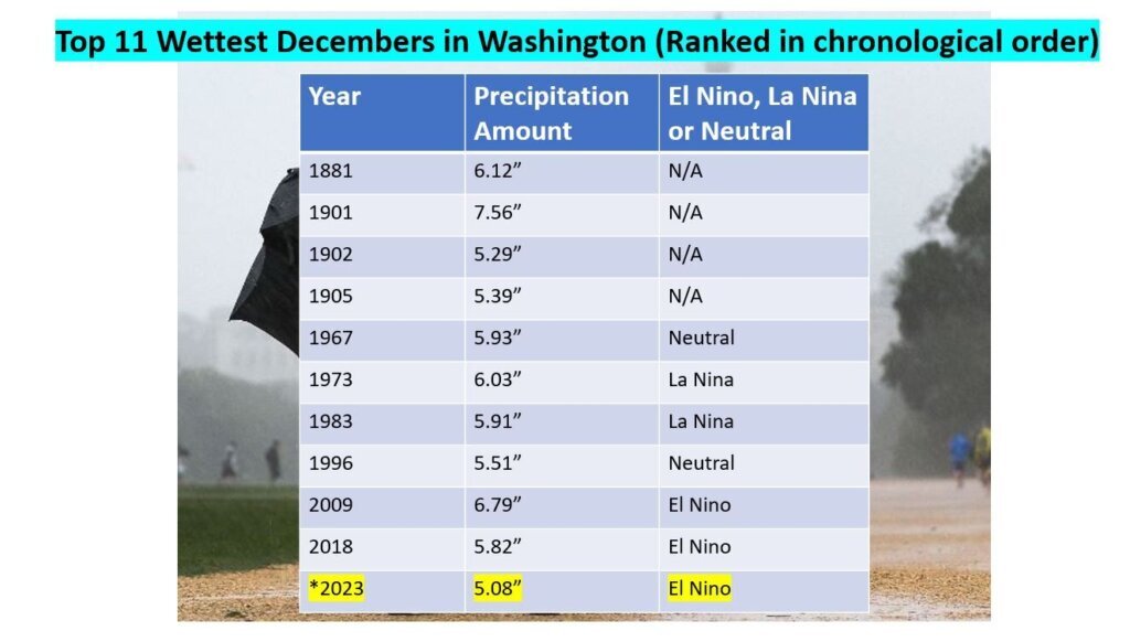
Even without the expected 0.50-1.0 inch expected Tuesday into Wednesday, this month ranks as D.C’s 11th wettest December.
The common theme with the most recent wet Decembers in D.C., as seen below, is El Nino.
Just one month ago, the Shenandoah Valley was in a moderate to extreme drought thanks to the dry autumn.
The same turn of events in D.C. has led to drought improvement along I-81. Extreme drought has been erased and moderate to severe drought coverage has decreased by a whopping 19% this month.
Charlottesville, Virginia, had its 13th driest autumn season with 6.04 inches of rain while December will rank in the top 20 for wettest with at least 3.77 inches of rain.
There is no sign of El Nino letting up until late spring, so a strong subtropical jet stream will likely enhance rainfall through the winter months. If the perfect recipe of moisture and cold come together, then D.C. could get a big snow, but based on trends, that won’t happen until late January or February. So stay tuned.