

WASHINGTON — The autumnal equinox is Sept. 22 at 4:02 p.m. It won’t feel like a change of seasons, however. The other season that it is right now of course is hurricane season, and the tropics are still busy.
Jose is being watched closely and it will be close enough to potentially bring some of us some showers.
Other than that threat, there will not be a lot happening this week while we are trapped in a strong ridge of high pressure in the eastern United States, while a deep trough of low pressure and cool weather sets up shop in the West.
Temperatures will be above average every day this week, but it will also be uncomfortably humid. Dewpoints will be in the low to mid 60s all week, which would make it feel as sticky as the mid-summer. Considering it’s mid-September, it might feel downright muggy to a lot of people.
With longer nights, temperatures have more time to cool to the dewpoints, and patchy fog may be a daily occurrence in the mornings.
Onshore flow between high pressure and the approach of Hurricane Jose will bring a chance for spotty showers on Monday at any time during the day, only isolated at most.
But Tuesday, even though landfall is not anticipated near the mid-Atlantic, the storm will be large enough for some of the outer bands to bring some showers to eastern parts of our area, mostly east of Interstate 95, in terms of highest likelihood.
The heavier rains would be along the beaches, and winds here would only be breezy at worst. As the center of Jose heads for New England, it will weaken, and the actual center of the storm may not make landfall at all.
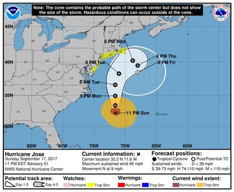
For the latest information and official forecasts concerning Jose (as well as Lee and Maria), check the National Hurricane Center.
[custom_gallery]
DAILY WEATHER HIGHLIGHTS
MONDAY:
Mild, muggy start with areas of fog
Staying mostly cloudy
Warm and humid
Isolated showers or drizzle
TUESDAY:
Mild, muggy start with areas of fog
Mostly cloudy, more peeks of sun likely along Blue Ridge
Showers possible along and east of I-95. Showers likely close to the Bay and southern Maryland
Warm and humid
WEDNESDAY and THURSDAY:
Warm and muggy start with patchy fog
Becoming partly to mostly sunny
Unseasonably very warm and humid
FRIDAY:
Warm and muggy start
Possibly not quite as warm, depending on cold front which may approach from the north
Editor’s Note: The WTOP Workweek Weather Blog is intended as an in-depth yet plain language summary of the business week’s weather potential in the D.C. area along with an explanation of the contingencies and uncertainties that exist at the time of publication. For the latest actual Storm Team 4 forecast, check out the link on the main WTOP Weather Page.